Rakaia river crossing
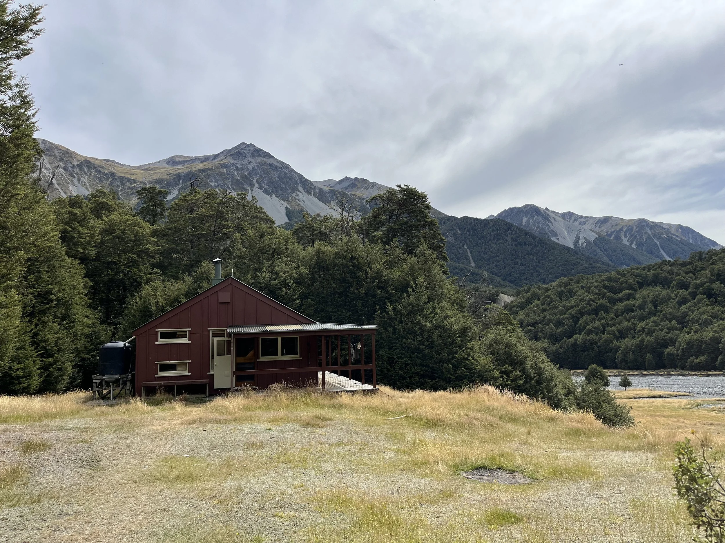
That day we stayed at Hamilton Hut (km 2227.3) and the plan was to either walk to Ryton River bridge at 2258.1 where supposedly there was plenty of space for tents. It was Friday, and Saturday weather promised a storm, so hopefully we’d walk to Lake Coleridge by noon the next day and hitch to Methven by the time the rain comes.
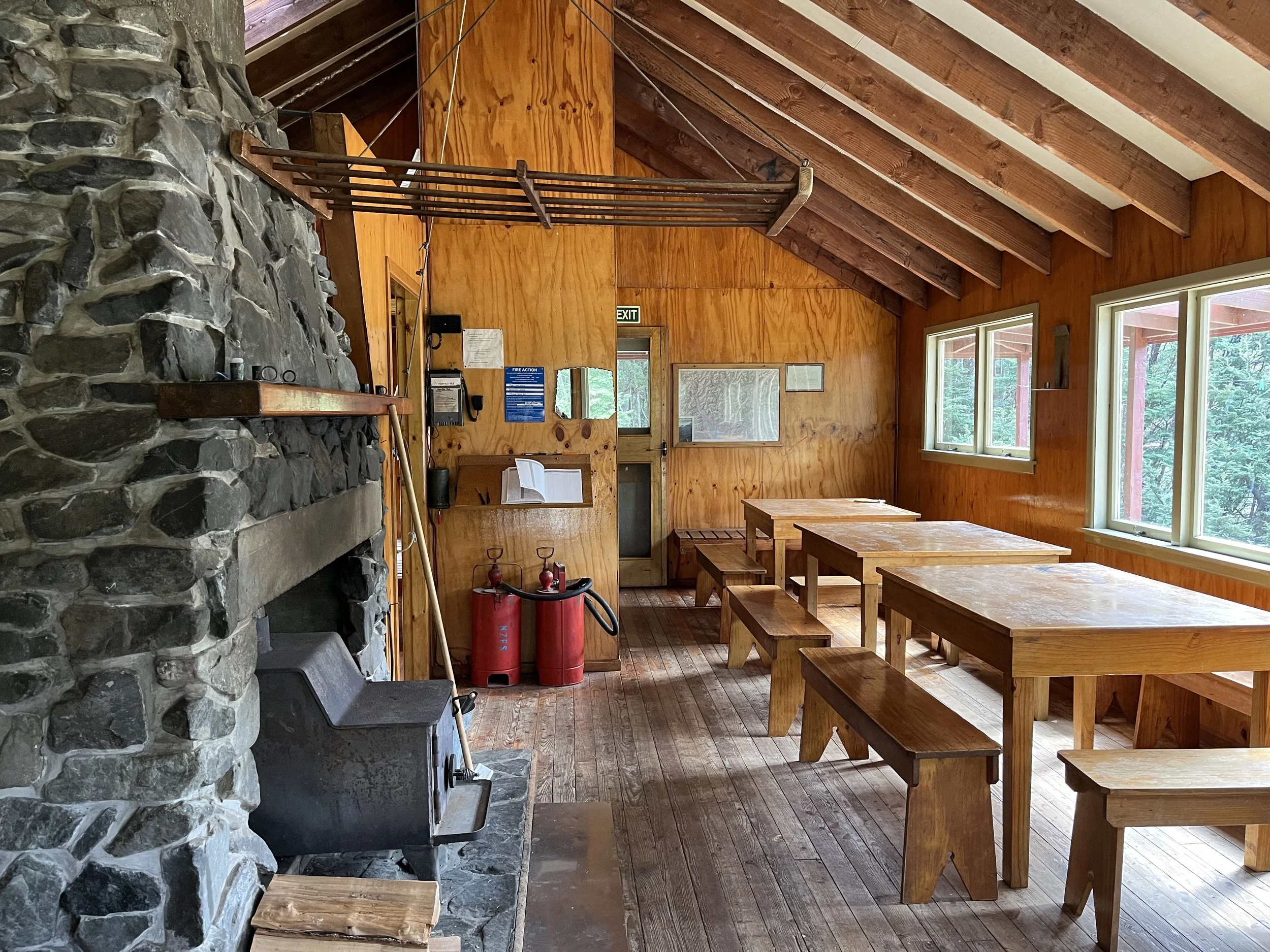
Hamilton Hut is one of the nicest huts along the TA – heaps of space and a nice view around. There’s even a giant stone fireplace in case you happen to be there in cold weather. That’s one of those huts you wished you spent your Christmas Eve in.
The day was shaping to be great – sunshine, a bit cold for standing around, but great for hiking. Until you get to the streams. It snowed in this place a week ago, and the water in the streams was freezing. At 07:30 am we had to wade in and out of them for about half an hour and at some point, I stopped feeling my feet. Thankfully, the sun rose from behind the hunches and made it instantly better. It was an easy walk and at quarter to 11am we were on a gravel road leading up to Harper campsite and that’s the place where our plans changed 180 degrees. See, this is the place where 4G reaches your phone.
For about half a month we’ve been toying with the idea of crossing Rakaia. Rakaia is one of the largest braided rivers in New Zealand. It was taken off Te Araroa trail and deemed unsafe to cross. To cross it, you would have to travel around 16km of riverbed of two rivers – Wilberforce and Rakaia. Crossing that would take a couple of hours, and if you study river flowcharts, water level on this river can rise more than three times in a matter of a 3-4 hours. Crossing it in the rain is just plain insanity, but even if it doesn’t rain where you are, those rivers are a confluence of many small streams from many different mountains, so if it rained somewhere to the West of you – you will feel it. Even if you started hiking the riverbed in a perfect weather, if it starts raining somewhere in the hills, by the time you reach the last braid (and the last braid is the biggest), it might be too full to cross, and the worst thing is- to get there you’ve already crossed at least one pretty scary braid, so to get to a safe place, you will have to cross it again. With water level rising fast – you could potentially get stranded between two impossible to cross braids and a riverbed is not a great place to be stranded on in the rain.
A friend I met earlier on the hike, who had a deadline and hiked ahead, brought up the thought somewhere around Timber trail and back then I thought this was a bit crazy. For him, maybe not, he’s a tall, fit and experienced hiker who, upon completing TA flew across the globe and jumped onto the AT and after nailing that one, started the CDT. For me, who is at least 30 cm shorter than him, less experienced and nowhere near the fitness level, crossing Rakaia was not on the list (I’m a 165cm, 51kg person). I’ll just hitch or walk around it. Still, I listened to his plans, asked him where and how to understand river levels and watched the river flow charts for more than a month. The closer I got to the river, the more I wanted to cross it, but still, I wasn’t going to risk it. Until the 4G reached me on that gravel road.
I checked the flowchart (https://www.ecan.govt.nz/data/riverflow/sitedetails/68526) for the hundredth time – it was 120 cumecs! People have reported crossing it at 140. We checked the weather – the rain is still only predicted for tomorrow and it hasn’t rained in the entire mountain range for almost a week. We walked to the Harper campsite to take a lunch break. By then the sun was a vicious ball of fire in a completely cloudless blue sky. The three of us had a discussion and unanimously agreed we wanted to try and cross. Conditions were perfect. I had pictures of routes hikers before us took. We roughly used the map of this man (https://camsalesbian.wordpress.com/2015/02/22/crossing-the-rakaia-and-rangitata-rivers/). There are some comments under the post about Algidus station being a private land, however this map (https://www.herengaanuku.govt.nz/maps/outdoor-access-maps) shows a road that is a public access road, so while everything around is, yes, private, if this map is correct, as long as you stick to the road, you should be ok. By “roughly” I mean that the river changes season to season, I don’t think you should blindly follow the line – follow it roughly and then use common sense to find best crossing spots.
All credits for this map go to the page in the picture.
We started walking the rocky riverbed, crossing small streams from time to time. They were wonderfully refreshing on a hot day like that. There were some sheep grazing around us as if it wasn’t really a place a huge river flows sometimes. We reached the biggest leg of Wilberforce. It was wide and fast flowing, but only knee-deep, so we waded across and aimed towards Mt. Algidus. After a while, a four-wheel track appeared, meaning there weren’t going to be any serious crossings till the dry land pinnacle between the two rivers.
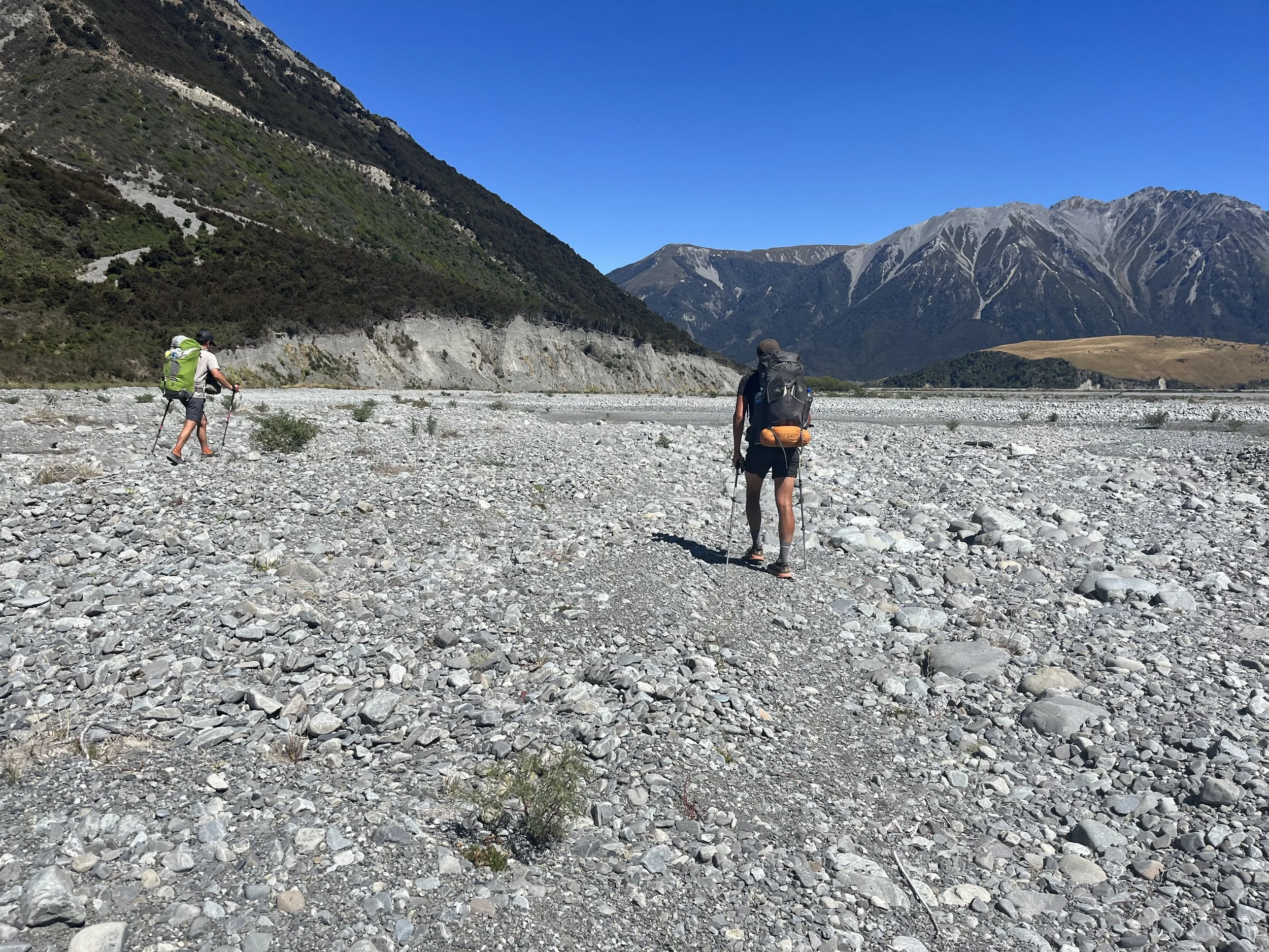
We exited onto a dirt road and were greeted by loud barks. A jeep with a bunch of dogs appeared ahead of us, but turned off into the private property while we continued on the dirt road. Nobody seemed to care that we were there. We were joined by some sheep that got spooked and instead of running away from us, decided to run ahead. The sheep ran into more sheep, who made an equally “smart” decision to run ahead and in 5 minutes there were literally hundreds of sheep running “away” from us by running in front of us. We, slightly unnerved by the chaos we caused, tried to stop and wait till the sheep realize they should simply go to the side, onto the wide fields instead of running along the dirt road. Alas, they would just slow their pace and start running as soon as we started moving. To make our shepherding experience even grander, they were soon joined by cows, so now there were hundreds of sheep plus a couple dozen cattle on a hike with us. The cows sounded war moo’s to which the cows some 200m away from us on another hill responded with running as well. This herd mentality was becoming ridiculously uncomfortable. I didn’t want to scare these guys. Finally, they gave up. Peace at last. On the background, far in the distance, was one of the best trail views – tall, snowy Southern Alps.
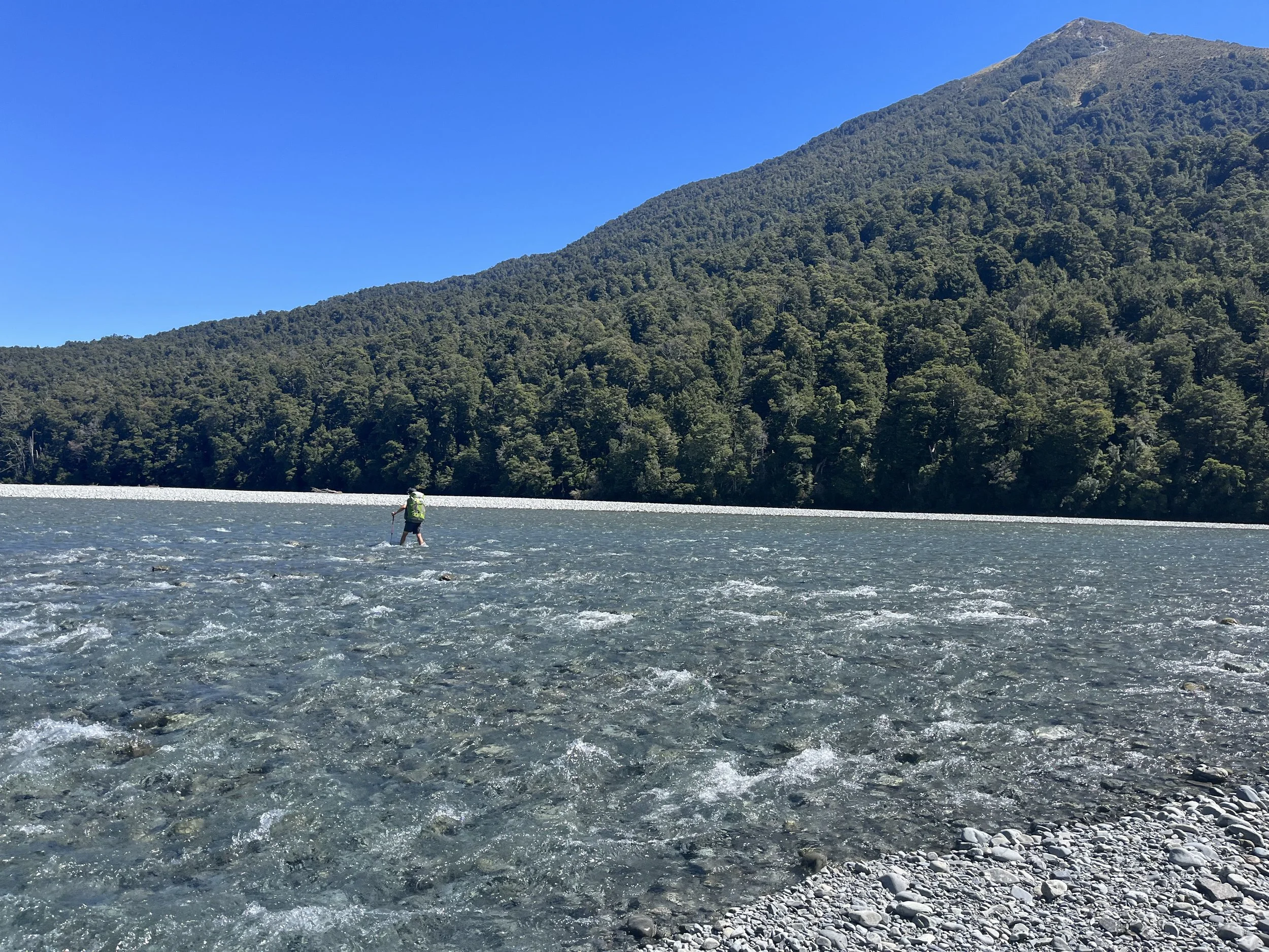
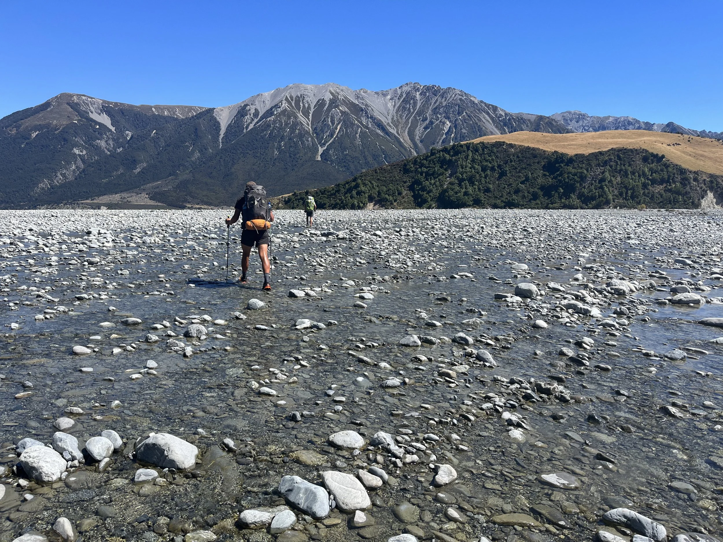
We entered Rakaia riverbed. The riverbed was shorter than the one before. We could see a little house on the other side we were aiming at. I checked the phone – 4G was back. I glanced at the river flow chart – 114 cumecs. It managed to fall even more! I have never seen it as low. Something was either broken or we were really lucky. If it was the latter – great, if it was the first – this day might just be way longer than expected and we were already quite tired. A couple of smaller streams and we reached a deeper-looking one. It was about 5 meters wide, but very fast. Not expecting anything unusual, we waded in, laughing about something, Tom being ahead, Kez taking a video and me trudging along. Suddenly Tom went from knee-deep to high-thigh in a step. Since we followed right behind, we had no time to react before doing exactly the same. Still laughing I felt I was not feeling as steady as I should. The water was reaching my butt now and pushing against my backpack, which Tom held just in case I was swept off my feet. Meanwhile Kez tried to hide his camera and hold a walking stick instead. Somehow, we got to the other bank, still laughing, but it was a good jolt we needed before the last braid, so we could actually take it seriously, since crossing more than 10km of small streams had almost left us disappointed at this “hazardous” river. We walked another 1 or 2 km and there it was, the last and biggest braid. We looked at the blue highway of flowing water – uncrossable. There was no way I was going to even try that. Even if you saw the bottom through the extremely clear water it was usually deeper than it seemed and in this one, you could just barely see it. It would be chest, if not neck deep.
You do not cross this in sane mind.
We went upstream to find a better place. It must have taken us another 20 minutes (and an episode of finding quick sand that swallowed my foot till its ankle) until we found a really wide spot that looked a bit shallower, tough still really fast. Remembering my recent crossing of the braid before this one, I felt slightly unnerved. Tom didn’t seem to have any fear in him whatsoever. He waded in and started walking up and down, finding the best route. We followed. The water reached high-thigh again, but thankfully never rose higher. I was shifting my legs along the rocky bottom, because lifting them would knock me off, leaning on my walking poles with all force. This was probably the hardest 20-30 meters I’ve ever walked. By the time I waded out, my legs and wrists felt like after a good one hour work out.
The biggest braid of Rakaia.
Us starting to cross the biggest braid.
We cheered successfully crossing the river and continued onto the road. It looked pretty deserted. When we were almost at the road, a car appeared, but no matter how much we waved and ran, it passed us, leaving a cloud of dust behind it and silence ensued. We reached the road, high-fived again for completing the river, found a little river stream of clean and cold water and stood. We’ll probably have to pitch a tent somewhere by the road. Let’s start walking and hopefully a suitable spot (or a car) will appear. Not even a 10 minutes after we started walking, we see a bus coming at us. The famous Methven school bus – the bus that drives school children via the same road and for 25 dollars takes hikers to and from Methven before he picks up the kids and after all of them are dropped off. The bus gets closer and we wave, happy. There appears to be one kid inside the bus. It’s just after 5pm. The bus should be back on the way to Methven soon. We can’t believe our luck. We didn’t know the bus’ schedule nor we ever planned to take it, since we didn’t plan crossing the river at all. In about another 10 minutes we see a cloud of dust and the bus drives up to us. We jump in and start rolling along a dirt road, blue Rakaia snaking along to our left. This was just the perfect day of perfect coincidences.
That day we walked about 35 km, 19 km till the harper campsite and another 16 km of the river according to my gps. It took about an hour for the bus to reach Methven, where it dropped us right at the doorstep of Snow Denn Lodge where we decided to stay for a zero day before continuing to the other river – Rangitata.
We ended up deciding to wait for our friends and stayed for 5 days, that being the longest I have ever zeroed.
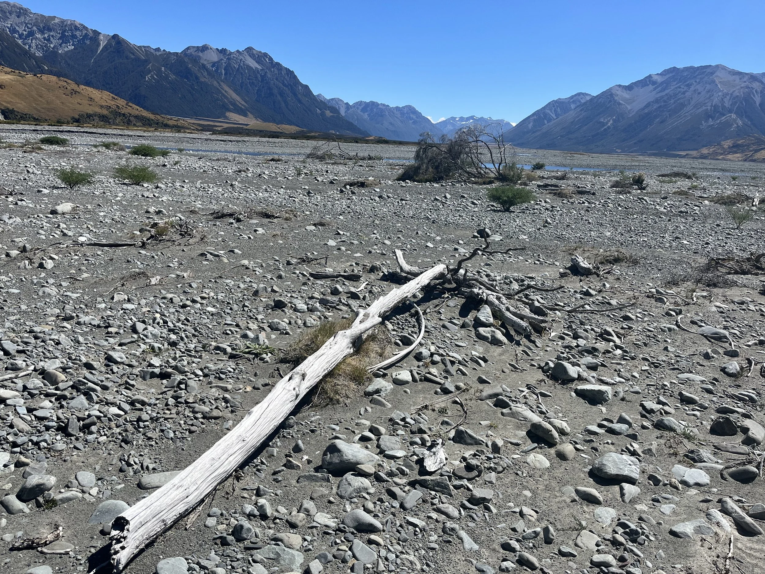
Looking back, I am glad I did the river. I really wanted some river crossing experience and this was definitely some good practice. And thanks to the clear skies, the views were incredible. The whole experience walking that desolate land of dry shrubbery, driftwood and perfectly smooth rocks in scorching sun was something of a post-apocalyptic scene. To this day I don’t know whether something was broken in the station where they measure the river flow, because that day it fell to 102 but was quickly back to 140 without any changes in the weather at all anywhere in the South Island. Maybe it was 140 all this time. In any case if the level was any higher, I think my legs would not have stood a chance of holding against the current. I have no idea what this river looks like at higher flow rates, but I would never want to find out. I’m happy the day went the way it did. A perfect river crossing.